Friends of Spenceville was formed to educate the public about Spenceville, and in so doing, preserve Spenceville as a wildlife and recreation area.
The Spenceville Wildlife Area, an approximately a 12,000 acre wildlife preserve managed by the California State Department of Fish and Wildlife, is a treasure that should be celebrated and protected for present and future generations.
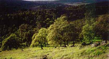
It is a place of multiple habitat types from blue oak woodlands and open grasslands with huge sheltering oaks to steep heavily wooded canyons. Both Dry and Little Dry Creek flow through the year and when March arrives, poppies, lupines, lilies and myriad other wildflowers species spread their color and fragrance over the hillsides and through the riparian woodlands providing habitat for many animal species. At least 175 bird species including the state and federally listed California Black Rail and Bald Eagle, have been seen in the area. The preserve's major stream, Dry Creek, is spawning habitat for endangered fall-run chinook salmon and steelhead trout. In some areas, Indian grinding rocks can be found near the stream and archeologists have identified Maidu dwelling sites.
The previous regional manager of the Wildlife Area stated that the area "has exceptional species richness and contains many game and non-game species in the unique and diminishing habitats. Spenceville contains the greatest contiguous public blue oak woodland in the tri-county area and connects with adjacent open space properties providing continuous habitat corridors. Not counting plants, at least six federal- and/or state-listed threatened or endangered species are known to use the wildlife area."
Friends of Spenceville has published "A Natural Guide to the Lower Sierra Foothills and the Spenceville Wildlife & Recreation Area", which you can obtain by e-mailing, calling or running into us out there . This colorful and informative map will guide you along the trails and introduce you to the flowers, birds and other animals and plants that live or migrate through Spenceville. It also covers the rich and interesting history of of the area.
HOW TO GET THERE: To get to the Spenceville Wildlife Area from Grass Valley, drive 12.5 miles west from Highway 49 in Grass Valley on Highway 20 toward Marysville. From the Marysville Area drive East on Highway 20. Turn south from Highway 20 at the Dollar General store near the turn off to Smartsville onto the Hammonton Smartsville Road. After .9 mile, take the left fork and continue on Chuck Yeager Road about 3.8 miles to Waldo Road and turn left. Continue along Waldo Road for 1.8 miles to the Waldo Bridge, which was built in 1901 to serve the now extinct towns of Waldo and Spenceville. After crossing the bridge, continue to the left along Spenceville Road for 2.3 miles until you arrive at the end of the road parking area and trailhead by the old cement bridge and the now restored Spenceville copper mine site. There are multiple turnouts and access points along the way since the turnoff onto Waldo Road.
To contact FOS: 214 Gethsemane St , Nevada City, CA 95959
(530) 264-6740 or randtthomas@sbcglobal.net
Thanks to Lonnie M. Rohde for material from her 1997 Senior Thesis Project at California State University, Sacramento, Dr. Nancy Ostiguy, Advisor.
This website hosting is provided by Succeed.Net Rural Broadband.