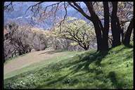
The Spenceville Wildlife Area ( SWA) is located approximately 45 miles north of Sacramento and can be reached via Highway 65 from the town of Wheatland or Highway 20 from Marysville. The Spenceville Wildlife Area is comprised of 11,213 acres of gently rolling hills that are characteristic of the Sierra foothills. Two thirds of the wildlife area resides in Yuba County with the remaining third in Nevada County. The reserve extends 10 miles from north to south and 4 1/2 miles east to west. Beale Air Force Base and numerous private landowners border the area (Rogers et al. 1996).
Toward the end of the Middle Jurassic (200 million years ago), an eastern moving island arc from 600 miles out in the Pacific met a western moving continent. The collision formed a 100 mile long and 100 mile wide area, known in geology as the Smartsville Block, named after a gold camp in the area. Due to the collision, the nearby rock developed the numerous high-angle faults of the Mother Lode. Water moving through the faults connected with the underlying magma of the Sierra Batholith. Gold compounds in the magma dissolved in the water and rose in the fissures, where the cooling gold fell out in the water as metal. So the Smartsville Block, docking in the Jurassic, not only doubled the size of central California but created the Mother Lode. (See "Assembling California" by John McPhee).
The gentle rolling terrain of SWA varies between 230 and 1,000 feet in elevation. The soil of the area contains generous amounts of clay and is shallow in depth. Underlying bedrock consists of metamorphosed volcanic rock (Rogers et al. 1996) commonly referred to as Serpentine or Greenstone. The outcroppings of this resistant rock type have been dubbed "tombstone rock" due to its likeness to thin, slightly rounded tombstones. A formation of significance is the large geological formation called the Foothill Copper Belt which extends along the western foothills from Shasta County to Fresno. The presence of this formation's copper deposit was responsible for the booming success of the town of Spenceville in the 1850's.
By the 1850's gold had been discovered in California and many people had emigrated from the east in hopes of striking it rich in the West. Emigrant trails wound throughout the area and evidence of old wagon tracks still exist within the Wildlife Area today. By the fall of 1850 mining in the Sierra foothills was in full throttle and Spenceville was no exception (BAL 1993). Small mounds created by miners to divert water from the stream channel in order to more easily find gold are still quite visible today. The actual town of Spenceville was established in the late 1850's when the Shasta Fresno Copper Belt deposit was discovered in the area. The town of Spenceville grew up around the mine and included a school, post office, general stores, and a hotel. Mining ended in 1915 and the mine was declared a "toxic pit" in 1989. The site has since undergone extensive remediation and revegetation. The contamination was present in Little Dry creek, Dry Creek, and the Bear River. The two elements of most concern at the Spenceville Mine were copper and zinc. Their presence was evident in the lack of vegetation around the mine after 85 years. Acid mine drainage formed from exposed geological deposits to the natural weathering elements of air and water. Pyrite was one type of deposit and was a byproduct of coal mining. Coal was a byproduct of the copper extraction at the Spenceville mine. This pyrite was oxidized and metals from the minerals became available for transport down streams during times of rain and/or flooding because of their soluble tendencies in the acidic conditions of acid mine drainage.
Open pit mining increased the surface area of the minerals that are highly
prone to breakdown and therefore acid mine drainage. There was a diverse microbial
community that survived in the acid mine drainage environment. Acidophillic
bacteria convert the energy found in inorganic chemical compounds into energy
usable for their life processes. They catalyze iron oxidation and facilitate
the acid mine
drainage event by making metals more available to the weathering process.
There are approximately 16.5 miles of significant streams containing flowing water at least most of the year (Rogers et al. 1996). Little Dry Creek, Cox Creek, and Jones Creek are maintained with water purchased by the Department of Fish and Game (Rogers et al. 1996) from the Nevada Irrigation District. Dry Creek is the only permanent stream at SWA and provides the area with high quality riparian habitat. There are over 40 small reservoirs or ponds at SWA of which 27 are filled by natural run off and 14 that are spring fed. In addition, there are 24 springs that provide extra water sources for wildlife in the area.At the north end of SWA is one of its greatest virtues, Shingle Falls or Fairy Falls as they were called originally. The two cascades, totaling nearly 90 feet, drop into deep pools along the course of Dry Creek.